Q.1.
Look at the map, it shows some of the main ocean currents of the world. Which of the following statements about the Canaries current is correct?

-
0%
The Canaries current flows northwards from Africa
-
0%
The Canaries current carries cooler water away from southern Europe
-
0%
The Canaries current is a warm water current
-
0%
The Canaries current flows along the east coast of Africa
Q.2.
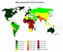
This map shows the HDI of most of the world's countries. For what geographical term is HDI an acronym?
-
0%
Highest Denominational Integer
-
0%
Human Development Index
-
0%
Human Degradation Indicator
-
0%
Human Development Indicator
Q.3.
This map is an example of:
-
0%
an Ordnance Survey map
-
0%
a Mercator map
-
0%
a plan
-
0%
a choropleth map
Q.4.
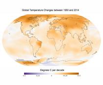
Which statement about changes in global temperature is correct?
-
0%
The countries along the equator have had the largest temperature increases
-
0%
Since 1950, the northern hemisphere has seen the largest temperature increases
-
0%
Overall, between 1950 and 2014, world temperatures have decreased a lot
-
0%
Brazil is the only country in which the temperature rose during the second half of the twentieth century
Q.5.
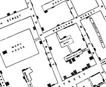
This is part of a map created in 1854 showing cases of the deadly disease cholera in London. How many cases of cholera were there in total on Portland Street and in the work house?
-
0%
25
-
0%
13
-
0%
8
-
0%
5
Q.6.
The map shows the main vegetation zones of the world. Which of the following is NOT a true statement?
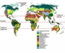
-
0%
Areas of temperate broadleaf forest are found only in the UK
-
0%
One area where tundra is found is the north of Canada
-
0%
Most of the world rainforest areas are found between the tropic of cancer and the tropic of capricorn
-
0%
Between almost all of the areas of tundra and other vegetation zones, you find the taiga biome
Q.7.
Based on the information given on the map of land use in Bosnia-Hercegovina in which of these towns are you most likely to find BOTH wine making and timber production occuring?
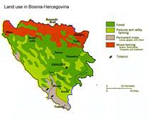
-
0%
Sarajevo
-
0%
Gacko
-
0%
Bihac
-
0%
Zenica
Q.8.
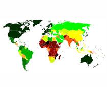
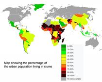
The map shows the percentage of urban populations living in slums. In how many African countries are 60 to 70 percent of the urban population living in slums?
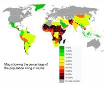
-
0%
4
-
0%
5
-
0%
6
-
0%
9
Q.9.
The map displays some of the key ocean currents of the Atlantic and Pacific Oceans. Which of the following descriptions is NOT correct?
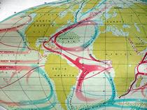
-
0%
The California current lies in the Pacific Ocean and flows southwards
-
0%
The Benguela current and Peru current transport cold water towards the equator
-
0%
The Canaries current and guinea current both carry warm water towards the equator
-
0%
The Brazil current and Gulf Stream carry warmer water towards the polar regions
Q.10.
Look at the map and decide which of the following is/are accurate?
-
0%
A characteristic of a less economically developed country is that a high proportion of the urban population lives in shanty towns or slums
-
0%
About half of the urban population of India live in slum areas
-
0%
According to the map most African counties are unlikely to be MEDCs
-
0%
All of the above