Q.1.
Which of the following scales would be appropriate to produce a plan of your school and school grounds?
-
0%
1:100,000
-
0%
1:500,000
-
0%
1:5,000
-
0%
1:50,000
Q.2.
Montreal is a city in Canada. Its coordinates are 45.5° N, 73.6° W. Which of the following European cities would be almost exactly due east of Montreal?
-
0%
London (51.5° N, 0.13° W)
-
0%
Berlin (52.5° N, 13.4° E)
-
0%
Oslo (59.9° N, 10.8° E)
-
0%
Lyon (45.8° N, 4.8° E)
Q.3.
If you were drawing a map of the Warrego Highway, how many cm would you need between Ipswich and Toowoomba?
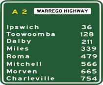
-
0%
128 at a scale of 1:25,000
-
0%
184 at a scale of 1:50,000
-
0%
92 at a scale of 1:75,000
-
0%
All of the above are correct
Q.4.
Using an OS map of the Peak District, the source of the river Ashop is in grid squareIt flows a few kilometres into Ladybower reservoir in grid squareIn which general direction does it flow?
-
0%
Slightly west of north
-
0%
Due south
-
0%
Slightly south of east
-
0%
Due east
Q.5.
This is a picture of an actual road sign in use in Switzerland. If you were using a road map with a scale of 1:100,000, how many cm from the location of the sign would Lugano be?
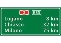
-
0%
8 cm
-
0%
32 cm
-
0%
75 cm
-
0%
100 cm
Q.6.
The photograph shows a trig pillar. What were they used for?
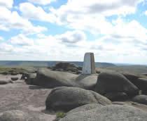
-
0%
They were used by the Ordnance Survey for accurate surveying to help them to produce maps
-
0%
They were built during the second world war for defence purposes
-
0%
They were used as emergency stations to help lost hikers
-
0%
They were used as rain guages
Q.7.
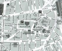
A group of students on an exchage trip to France were given a town map. They needed to get to the station (marked B on the plan) as quickly as possible. They were at point A on the map. In which direction did they need to walk?
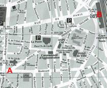
-
0%
South east
-
0%
South west
-
0%
North west
-
0%
North east
Q.8.
The Togolese Republic in Africa lies on the Prime Meridian of the World. In which direction is it from London?
-
0%
North
-
0%
East
-
0%
South
-
0%
West
Q.9.
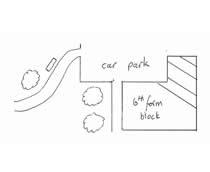
The scale of this plan is 1:5,Each grid square measures 2 cm x 2 cm. What area is represented by one grid square?
-
0%
0.01 square kilometres
-
0%
1 hectare
-
0%
10,000 square metres
-
0%
All of the above
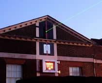
Q.10.
The photo shows a picture of Leeds, a large city in the UK. On an OS map, scale 1:50,000, a student drew a line, direction 90° east for 2 cm then continued it for 2 cm, in direction 180° followed by 2 cm in direction 270°. In the landscape, how far away from the starting point is the end point?
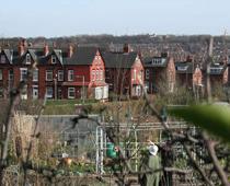
-
0%
0.5 km
-
0%
1.0 km
-
0%
2.0 km
-
0%
0.0 km